
San Juan Mountains is the twenty-third installment of Finding My Way Home. To view the previous installment, click here. If you wish to start from the beginning, click here. This is the ongoing story of the six years I spent as a vagabond photographer.

There are so many places in this part of Colorado I want my kids to see. I spent some of my early childhood in this area, and would love to show them some of the places I lived at the age of seven or eight. But, time is short and we can’t do it all. We settle on a hike in the Black Canyon of the Gunnison National Park. We choose the hike to Exclamation Point, mostly because I love the name of it! It’s a fun day and a nice walk. The afternoon thunderstorms are sometimes intense, per usual in this part of the country. I’m grateful that we get a reprieve and stay dry on our hike.

Also over the next few days, my son needs to gather supplies for his upcoming adventure with the Southwest Conservation Corps. He will be living in the back country for at least a week at a time, so he needs a tent, sleeping bag, warm socks, and other things on a list they have given him. We hit up some thrift stores, consignment shops, and used sporting goods trading posts. Ultimately, we decide that a new tent is needed, while other things can be purchased used.
I’m glad I’m able to help with these items. I’ve had financial ups and downs since going on the road. Luckily this time, the up has coincided with my son’s need for backpacking gear.

After a farewell breakfast with my Aunt Sally, we head off to Ridgway State Park. I want to explore a bit in that area before moving on to Bayfield, near Durango, where I have a reservation for the month of September.
My daughter and her partner have gone on to explore more of Colorado. And, after a night at the state park, my son heads south to check in and get ready for his SWCC hitch. Alone again, I decide to explore Ouray, Silverton, and Telluride.
When I say explore, I don’t really mean exploring the towns. These are high-dollar tourist destinations, and I’ve just spent any extra money I had on back country necessities. Anyway, I’m more interested in exploring the scenery of the San Juan Mountains around the area where these towns are located, which is what made them popular tourist destinations to begin with.

There are two routes I can take when I go to Durango/Bayfield. Both routes are high in elevation and go over the San Juan Mountains. The one I am familiar with and have driven before is highway 145 over Lizard Head Pass and through the town of Dolores. It’s an enjoyable and gorgeous drive that I made a year ago in the opposite direction. The distance this way is about 160 miles.
The other possible route is highway 550 from Ouray to Silverton and on to Durango. This is the famous “Million Dollar Highway,” so named because it reportedly cost a million dollars a mile to build when it was constructed in the early 1920’s. The distance this way is a little over 80 miles. I have talked to other RV’ers about this road and most have said it is scary to drive. A few people said it was no problem at all and nothing to fear. I’ve decided to drive it in my little car before making the decision to take my motorhome there.

I’m so glad I went over Red Mountain Pass in my car first. Wow! What an incredible drive. But, way too narrow, winding and vertigo-inducing to drive in a 34-foot motor home towing a car. My friends who have done it—my hat’s off to you. You are much braver than I. I will spend the extra hour taking the long way around, thank you very much.
Lots of beauty to check out in this part of the country. Also, lots of not-so-beautiful remains of mining operations and scars on the land. Extraction of massive amounts of gold, silver and other metals from these mountains went on the late 1800’s and into the 1900’s. Cleanup and restoration is ongoing, more than a hundred years after mining operations ceased, and most of these mines will never be completely restored.

I try to imagine what it must have been like in those days. The heady infatuation with riches to be gained and good times to be had. People living in the moment with nary a care about future generations or the damage being done. It strikes me that this is what we do. All of us. We just try to live happy and prosperous lives, not knowing (or not wanting to believe) there will be consequences later. Thinking back to my time in Wyoming, I remember the giant, open-pit coal mines. And I realize we are still doing it today. Even as we try to clean up our past, we are making a mess for the future.
On my way back from Silverton, I visit some of the attractions around Ouray. One of these is Box Canyon Falls Park. Even though it’s technically a canyon, it feels more like a cave. There is very little light that makes it down to the bottom, where the metal walkway for visitors has been constructed. The sound of thundering water and the mist in the air is breathtaking and invigorating. I am disappointed to discover that photos are next to impossible in these conditions. That explains why none of the brochures or websites had pictures of the waterfall. I will just have to save this experience in my memory.
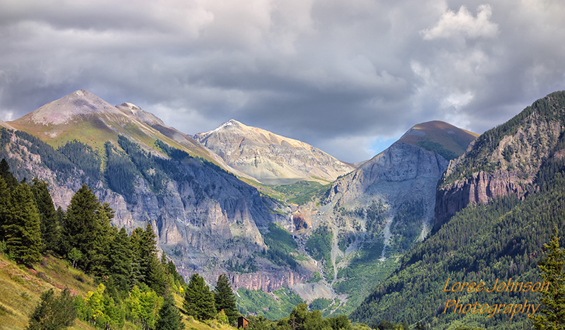
The next day, I travel to Telluride. Set in a canyon, below the backdrop of the towering San Juan Mountains streaked with gushing waterfalls, the town is a sight to behold. This place is a premier destination for skiers in the winter, and off-roaders in the summer. As I make my way to the edge of town, I can see Jeeps slowly progressing into town via numerous precarious switchbacks above. Downtown is filled with high-end shops catering to wealthy visitors. I see fliers posted around town for several upcoming events, but I am more interested in the waterfalls. Without a four-wheel-drive vehicle, I cannot get close to any of them. I’m grateful for my 70-200mm lens, which allows me to zoom in on features of the landscape that are otherwise out of reach.

On my way back to camp, I stop at Chimney Peak overlook, just in time to catch the sunset’s golden glow on the storm clouds developing over the mountains. Feeling quite satisfied with my explorations of the area, I start preparing for the next leg of the journey.

I have a reservation for a full month in Bayfield, which is just outside of Durango. My hope is to capture the transition from summer to autumn in the mountains of southwestern Colorado. Also, I will be nearby when my son has a break from his back country volunteering, and close enough to visit with my dear friend Colleen.

I’m looking forward to staying in one place for a month. which will allow me to take care of some business. As I was leaving Rocky Mountain National Park, on my way to Yampa River State Park, a few weeks ago, a rock flew from a big rig going in the opposite direction and cracked my windshield. The rock was about the size of a ping-pong ball, and it made a starburst crack nearly the size of a grapefruit, so the windshield will have to be replaced. Motor home windshields cost thousands, but luckily, my insurance deductible is only five hundred dollars. Hopefully, I can find a mobile repair and have it replaced in the RV park.

Beautiful thank you
My pleasure! Thanks for stopping by.